 Road construction in landslide areas, Ethiopia
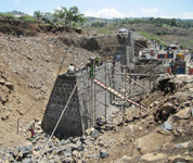 Landslide investigation and design of stabilisation
measures, Ethiopia
Landslide investigation and design of stabilisation
measures, Ethiopia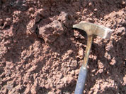 Prospecting and use of cinder (scoriaceous) gravels in low-volume road construction in Ethiopia
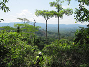 Mine haul road route selection, Liberia
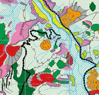
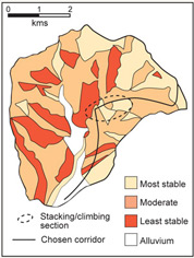 Landslide susceptibility mapping, Nepal
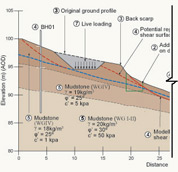 Soil slope stabilisation
Recent and Ongoing Projects
A selection of recent and ongoing projects:
 Summary of landslide densities recorded following the 2018 wet season along CRRPAM project roads
 An example of a Laos landslide
 Rural road infrastructure in Uganda
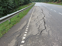 Cracking to road carriageway due to a fill slope failure along the Ntungamo-Kabale road
 Detailed Aerial Photo Interpretation
 Landslide investigation and design of stabilisation
measures, Ethiopia
Landslide investigation and design of stabilisation
measures, Ethiopia
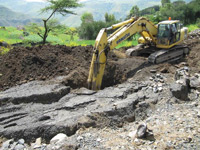
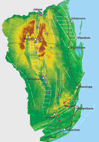 Prospecting for calcrete as a source of road
construction material, Mozambique
Prospecting for calcrete as a source of road
construction material, Mozambique
Landslide vulnerability assessment, Laos. As part of the CRRPAM* project undertaken by Sweco for the Ministry of Public Works and Transport, Laos, Hearn Geoserve Ltd carried out an assessment of the impacts that landslides have on the mountain road network and developed a procedure for vulnerability assessment. The outcome was a GIS-based landslide vulnerability classification of the road network forming the project’s study area and a dataset of large landslides. Training was given to Department of Roads staff in the collection of landslide data, the maintenance of a landslide inventory and the update and rollout of the vulnerability assessment. The management of landslide hazards on the road network was also targeted through workshop and field training. *Climate Resilient Road Planning, Asset Management Support and Capacity Building. Click here to view the video
Development of a Landslide and Road Reserve Management Toolkit (LRMT) and Landslide Management Guideline (LMG), Uganda. Hearn Geoserve Ltd and ICS Engineering and Environment Ltd, Uganda, have worked with the Uganda National Roads Authority (UNRA) to develop landslide management tools for use in the road sector. The LRMT is a web-enabled, GIS-based system for recording landslides that impact the road reserve and the wider road corridor. It provides station managers with the facility to input data on landslides as they occur, and interrogate the dataset that already exists for maintenance management and planning purposes. The system was developed by Independent Software Ltd. The LMG provides guidance on the identification, investigation and mitigation of landslides that impact the road reserve, and focuses on geotechnical and especially low-cost bio-engineering techniques of slope management. Development of the LMG was assisted by Living Resources Ltd. The project itself was funded through DFID’s Research for Community Access Partnership. Click here to view the full report
Third part review of reservoir slope stability, Albania, including detailed interpretation of aerial photographs and preparation of geomorphological maps. Undertaken for Multiconsult ASA, Norway
Team Leader and Researcher Specialist for the prospecting and use of cinder (scoriaceous) gravels in low-volume road construction in Ethiopia. Undertaken for the Transport Research Laboratory on behalf of DFID
Feasibility study for haul road route selection through mountain terrain at the West Nimba iron ore mining facility, Liberia. Undertaken for URS Infrastructure & Environment Ltd on behalf of ArcelorMittal
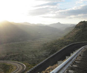
Landslide investigation and design of stabilisation measures, Ethiopia. Undertaken for URS Infrastructure & Environment Ltd for the Ethiopian Roads Authority
Review of climate change and geohazard impacts on rural road access in Africa.
Undertaken for Crown Agents on behalf of DFID
Prospecting for calcrete as a source of road construction material in Mozambique using satellite image interpretation and field mapping techniques. Undertaken for Transport Research Laboratory, UK on behalf of DFID and Administraçăo Nacional de Estradas
Mozambique Engineering geological and geotechnical management of the design and construction of a new road across the Blue Nile Gorge, Ethiopia.Undertaken for URS Infrastructure & Environment Ltd on behalf of the Ethiopian Roads Authority
Peer Review of Earthworks Specifications and State-of-the-Art manuals in route selection, geotechnical design and the use of laterites and sand in low cost road construction. Undertaken for Crown Agents on behalf of DFID to develop optimum alignments and designs in a range of environments.